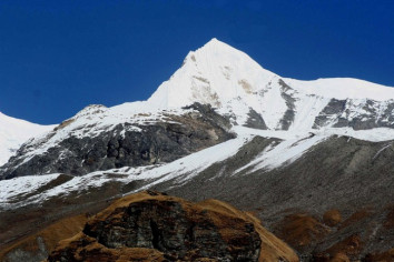
Gyalzen Peak, also known as Leonpo Gang East or Gyalgen, is located in the Himalayas with an elevation of 6151 meters (20180 feet). It has the Peak ID GYLZ. The peak was first ascended on May 11, 1955 AD by a team consisting of Monica Jackson, Elizabeth Stark, Mingma Gyalgen Sherpa, Ang Temba Sherpa, and Gyalzen Peak.
Gyalzen Peak, standing at an elevation of 6151 meters, is situated in the Jugal mountain range. This prominent peak lies on the border between Bagmati Province in Nepal and China. Specifically, it is located within the Sindhupalchok district of Nepal, falling under the jurisdiction of Jugal Gaupalika.
Notably, Gyalzen Peak is positioned approximately 6.8 kilometers east of Dorje Lakpa, a towering mountain with a height of 6966 meters. Additionally, it is about 5.7 kilometers northwest of Yagri Peak.
Here's a summary of the geographic relationships:
- Gyalzen Peak: Elevation 6151 meters, situated in Jugal mountain range.
- Location: Sindhupalchok district, Nepal, within Jugal Gaupalika.
- Distance to Dorje Lakpa: Approximately 6.8 kilometers to the east.
- Distance to Yagri Peak: Roughly 5.7 kilometers to the northwest.
Gyalzen Peak Overview
| Gyalzen Peak Overview |
|---|
| Other Name | Leonpo Gang East, Gyalgen |
| Peak ID | GYLZ |
| Status | Opened |
| Elevation | 6151 M / 20180 FT |
| Latitude | 28º 11' 02" |
| Longitude | 85º 50' 30" |
| History | 1st ascent on
11 May, 1955 A.D
1st ascent by
Monica Jackson,
Elizabeth Stark,
Mingma Gyalgen Sherpa,
Ang Temba Sherpa,
Gyalzen Peak |
18 Days Gyalzen Peak Climbing Itinerary
Day 1:Arrive Kathmandu
Day 2:Climbing Pre preparation
Day 3:Drive from Kathmandu to Kyansing
Day 4:Trek to Dippu Village
Day 5:Trek to Ne-Pemasal
Day 6:Acclimatize
Day 7:Trek to Base Camp Gyapkharka
Day 8:Acclimatize
Day 9:Trek to High Camp- Yang Kharka
Day 10:Acclimatize Climbing Pre preparation
Day 11-13:Climbing period summit (6151m) Gyalzen Peak
Day 14:Trek to Dippu
Day 15:Trek to Kyansing
Day 16:Drive to Kathmandu
Day 17:Departure
Location Details:
- Province: Bagmati Pradesh
- Mountain Range: Jugal
- District: Sindhupalchok/NC
- Municipality/Rural Municipality: Jugal/NC
Nearest Help Center (from the basecamp along the caravan route):
- Health Centre/Post: Bokse, located 50.9 kilometers away.
- Nearest Settlement: Tharpu, approximately 5.2 kilometers away.
Royalty Fees:
- For Nepalese climbers: NRs 4000 in spring, NRs 2000 in autumn, and NRs 1000 in winter and summer for expedition.
- For Foreign climbers: USD 250 in spring, USD 125 in autumn, and USD 70 in winter and summer for expedition.
How to Get There:
- From Kathmandu, you can drive to Kothe via the Arniko Highway.
- Caravan Route: Barabishe-Chako-Listimai-Bagan-Bahirav Kunda-Base Camp (BC).
- Caravan Route Length: 61.2 kilometers through Jalbire.
- Climbing Route Length: 19.3 kilometers.
- Duration: The expedition typically lasts for 40 days.
Location Details:
- Province: Bagmati Pradesh
- Mountain Range: Jugal
- District: Sindhupalchok/NC
- Municipality/Rural Municipality: Jugal/NC
Nearest Help Center (from the basecamp along the caravan route):
- Health Centre/Post: Bokse, located 50.9 kilometers away.
- Nearest Settlement: Tharpu, approximately 5.2 kilometers away.
Royalty Fees:
- For Nepalese climbers: NRs 4000 in spring, NRs 2000 in autumn, and NRs 1000 in winter and summer for expedition.
- For Foreign climbers: USD 250 in spring, USD 125 in autumn, and USD 70 in winter and summer for expedition.
How to Get There:
- From Kathmandu, you can drive to Kothe via the Arniko Highway.
- Caravan Route: Barabishe-Chako-Listimai-Bagan-Bahirav Kunda-Base Camp (BC).
- Caravan Route Length: 61.2 kilometers through Jalbire.
- Climbing Route Length: 19.3 kilometers.
- Duration: The expedition typically lasts for 40 days.

 Adventurous Save $100
 Adventurous Save $200